Cuchara Recreation Area Ride Report
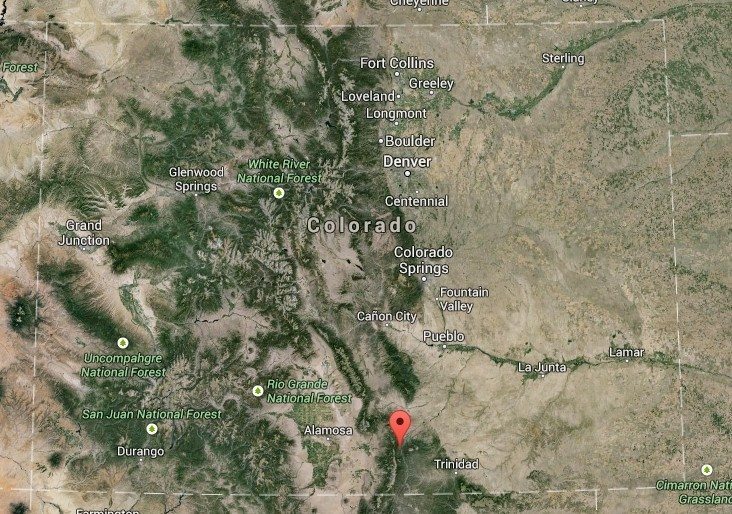
The Cuchara Recreation Area is located in the San Isabel National Forest in Southeast Colorado. There are two main trails inside the park, Indian Creek Trail and Trinchera Peak Trail. Indian Creek Trail is by far the longest of around 20 miles, Trinchera, on the other hand, is relatively short but is all uphill. The Trails mostly consist of large rocks and hard pack. The trails run along the side of the mountain, so rainwater doesn’t pool in ruts along the trail, resulting in a dry hardpack that is almost always tacky. In other words, perfect.
Indian Creek Trail
The Indian Creek Trail is long and winding and descents 3,000ft from Bear Lake campground to the Spring Creek trailhead. There are a few tight switchbacks on the main trail I wasn’t expecting, I turned to go down the hill, my front tire hung up on a rock, and I gently fell over… I felt super cool, too bad; no ladies were there to see that!
Trinchera Peak Trail
The Trinchera Peak Trail right off of Blue Lake campground is only 3 miles long, but from the Blue Lake campground to the end of the trail is a 2,690ft climb. The trail is wide enough for Jeeps and side by sides, so you will have plenty of space when taking a dirt bike up the trail.
Elevation
The altitude of the Cuchara Recreation Area will affect you and your bike. Make sure your bike is tuned to accommodate the lack of oxygen in the air. If you are not used to the attitude (like me), budget an extra day when you get there to get used to it. This will give you time to explore the San Isabel National Forest, and will also prevent you from passing out on the trail. (Usually a good thing)
Weather
The weather is unpredictable at best. The sun will be shining while rain pours kind of unpredictable, so be ready for anything. The mountain stays snow-covered through spring, and some snow may still be on the trails in June. The weather is so unpredictable due to the altitude. The Cuchara Recreation area is between 8,000ft and 12,690ft above sea level. Add to that the turbulent air currents affected by the mountains and who knows what you’ll get.
Riding Fees?
Because you are riding inside the San Isabel National Forest, you will need a Colorado OHV Permit. I would suggest buying your permit as soon as you get into Colorado. They are surprisingly hard to come by in the small towns surrounding the forest.
Cuchara Camping
Camping inside the park is not necessary to access the trails; there are full-service RV parks to the north in La Veta, and to the south in Trinidad. La Veta is much closer and easier to get to from the Cuchara Recreation Area because you don’t have to go over a mountain like you do to get to Trinidad. Staying in La Veta also gets you closer to trailheads that start outside the national forest boundaries.
That being said, I highly recommend staying in either the Blue Lake or Bear Lake campground if you have the opportunity (and a small enough camper). Blue lake is right on the Trinchera Peak trailhead, and Bear Lake is on the Indian Creek trailhead. Both lakes are beautiful, and If you are a mounting biker, or hiker, this is a great place to spend days exploring.
Cuchara Recreation Area Final Thoughts
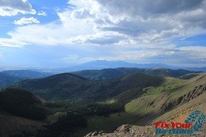
The Cuchara Recreation Area is a destination ride. I would recommend at least a week exploring the San Isabel National Forest. Make sure to bring a camera, even though no photos can do the Colorado view justice.
[table id=13 /]
Cuchara Colorado Riding
- Video: Cuchara Recreation Area – Trinchera Peak Trail Ascent Full GoPro
- Video: Cuchara Recreation Area – Trinchera Peak Slideshow
- Video: Cuchara Recreation Area – Indian Creek Trail GoPro
- Cuchara Recreation Area – Indian Creek Trail Photo Gallery
- Cuchara Recreation Area – Trinchera Peak Photo Gallery
- Video: Cuchara Recreation Area Ride Report – Aug 20th, 2014
- Ride Report: Cuchara Recreation Area – Aug 20th, 2014
- Video: Trinchera Peak Trail End